Discover and learn how a GIS program can help organize the management of key infrastructure assets!
[vc_row][vc_column][vc_video link=”https://youtu.be/cftVlMekXno”][/vc_column][/vc_row][vc_row][vc_column][vc_column_text]
Geographic Information Systems. Think about it.
GIS locates assets in the field with Global Positioning System accuracy. GPS is a satellite-based system that, in the right conditions, can hone-in on an object from space within a few centimeters. Every time you search that asset, the results are repeatable. So now you understand the Geographic part, let’s talk about the Information part. GIS is a means of managing data. It’s come a long way from its roots assisting municipalities and authorities make the quantum leap from a massive paper mapping system to the cloud. Migrating away from a system used for generations that was tangible, to one that shoots your data into the universe and back was a hard sell. Especially in the face of complications like fear of change, data maintenance, software and hardware upgrades, changing staff, and the commitment of a steering team who bought into the concept. Did I say fear of change? It’s no wonder why it took so long to catch on.
Crossroads
GIS was at the crux of altering our entire mentality about managing the workflow process, namely location of assets in the field, historical data about installation and maintenance, repair and/or replacement scheduling, and new or relocations. Re-training our brains to trust how the integrity of our data could be safely maintained and managed while we could barely grasp the overall concept was as foreign as understanding how Thomas Edison lit up a light bulb! But we’ve finally accepted that how it works doesn’t really matter, just that it does.
How a GIS Program Works
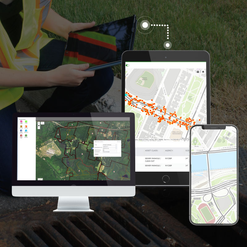
The easiest way to explain it is to talk about fire hydrants. An average township in Anywhere, USA might have a few thousand hydrants township-wide. All of them need to be inspected, flushed, and painted on an ongoing basis. Using a paper system to keep track of all of this, a worker had to get in a truck, plan-in-hand, drive to each hydrant which began by locating it. If it had become hidden due to vegetation overgrowth, an altered roadway setback, or relocation due to development, it might take hours to find. Perhaps someone failed to update the change on the plan. As-builts are notorious for being inaccurate.

Enter GIS, which records the location of each hydrant using GPS accuracy. If the satellite says it’s there, it’s there. If not, you have a different problem. Above is a GIS asset management dashboard that can be sorted to show you any amount of information about your hydrant system. There are drop-down features that enable you to add-in all kinds of details including asset inspections, condition, photos and videos, risk of failure, and service calls. All of which will aid officials to analyze the system for maintenance and capital project planning. These web-maps also enable you to view one street at a time or an overlay of the entire town or county.
Now that you get the concept, there’s more. GIS programs can be customized around your specific asset. Whether your assets are in the field or within a facility, the same capabilities apply. All of this information can be collected and shared from the field to the office in real-time using an iPad or other, mobile device. This is huge! The moment a field tech finds an asset with a problem, they can issue a digital work order for repair. Once the repair is finished, that technician can close-out the ticket and share with anyone, anywhere. Revolutionary right? No more paper, no more getting lost.
GIS & UAS
As GIS has developed, it’s being leveraged to manage many more project types that require large data management. We’ve paired using GIS with UAS (drones) to help energy companies record information collected by drones. They use thermal sensors that detect vegetation growth on their assets, all of which can be recorded into a GIS program. When you have miles of power line towers or solar fields to monitor, this becomes an invaluable time saver. Especially when vegetation grows so high it would be difficult for a field technician to physically reach an asset. In this case, drones can fly overhead to send video and photographic imagery to field crew, so they can develop a plan of attack.
Energy & Emergency Management
UAS geo-referenced imagery is also being incorporated with GIS to inspect the integrity of miles of waterfront, roadways, pipelines, and water distribution systems. Great for delivering detailed inspection reports! Having this capability is especially important during emergency situations. For example, you’ve had a lot of rain and a slope on a roadway collapses. A drone could be sent out to safely inspect the problem from a remote location to generate detailed visuals. These can be transferred into a report by a GIS program. Then, with only an iPad, you can generate work orders for an emergency shut-down notification and schedule traffic control and repairs.
Going back to municipalities, communities are now even using GIS to map locations to coordinate planned events including parades, commemorations, charity and sporting events, festivals, even emergency management activities. Information can be accessed for location, hours of operation, parking areas, restroom availability, ADA amenities, parade routes, costs, and other special instructions.
Info Highway
The more you use the system, the more efficient you become. Recently, one of our GIS project managers reported that he collected sub-centimeter location data for over 530 assets in less than 5 hours of time in the field. This breaks down to 34 seconds per feature. Location data and high-resolution photos were collected for traffic signals and signs, stormwater inlets and manholes, guard rails, ADA ramps and more along a 1.25 mile stretch of roadway. How’s that for a statistic? If you think that’s impressive, you should call us. Want more information or a private presentation on this topic? Contact Suzanne Zitzman, GISP at szitzman@maserconsulting.com or Michael Kolody at mkolody@maserconsulting.com.
Maser Webinar Series
This article is part of our Maser Webinar Blog Series. We turned directly to the experts who were excited to share their latest technologies, insights and strategies. If you have questions or would be interested in a Lunch and Learn about any of the topics covered, feel free to reach out to our presenters![/vc_column_text][/vc_column][/vc_row]