Month: October 2020
-
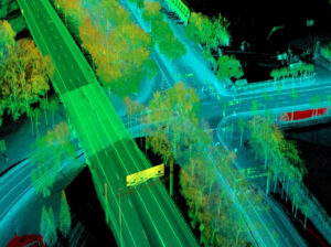
Mobile LiDAR Applications for Pavement Projects
Why Mobile LiDAR is Ideal for Mapping Pavement Projects Whether you are changing traffic flow at an intersection or working on a highway, pavement projects involving roadway corridors require engineers to understand the features and conditions they are working with. Using Mobile LiDAR for mapping long roadway corridors and associated features is ideal because it…
-
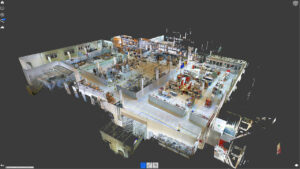
Advances in Terrestrial Laser Scanning
Terrestrial laser scanning aims to capture reality at a rate of up to two million points per second. From its inception to this very moment, it has improved at lightning speed. The training time required, complexity of the technology used, accuracy, field of view, cost, and possibilities of what laser scanning can be used for…