
Terrestrial laser scanning aims to capture reality at a rate of up to two million points per second. From its inception to this very moment, it has improved at lightning speed. The training time required, complexity of the technology used, accuracy, field of view, cost, and possibilities of what laser scanning can be used for is markedly better now than it was in the past, which means exciting possibilities for the future.
If You Want to Know Your Future, You Must Look at Your Past
You might think of the original Rat Pack, beehive hairdos, or the moon landing when you think of the 1960s, but did you know that this was also when laser scanning started being used by surveyors? These early scanners took hours to complete a scan. Not only was collecting data a heavy lift—so was the equipment. Weighing in at about 27 pounds per unit they were also cumbersome. Scanning was limited by the fact that in the 1960s computers were not what they are today. Still, the vision was there. The idea of capturing reality with laser scanning was born… it would just take some time to develop.
By the 1990s, the scans still had limited field of view (FOV), but improvements were on the way. For example, 2006 brought Leica HDS 6000, with its 150 ft range and 360 degree by 270-degree FOV. The equipment became lighter, easier to use, and more accurate as time went on, and as computers and hand-held smart-devices advanced.
Terrestrial Laser Scanning Today
While the survey equipment was awkward and heavy in the past, laser scanners are now highly portable, and their small size means that they can be placed in tighter spaces. They can be turned upside down, run with an iPad or a phone, so when working on a site that is dangerous for a human to be operating the scanner, you can activate the scanner from a safer location. They are often less than ten pounds, so they are light in addition to being small.
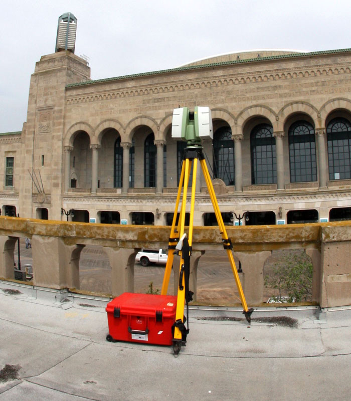
Back in the 1960s, the technology was so complex that training time was long and complicated. Today, most of the equipment is “press and go.” A scan with imagery can be completed in under a minute. Scans today produce incredibly accurate and detailed results with full scan coverage, and many have the option to include HDR color photography. Plus, these scanners can produce quality imagery, audio, video as well as integrated with GIS capabilities. Again, today’s scans are capturing reality. In fact, surveyors now can use live scanner tracking on a tablet, which means they can see everything in real time in the scans while they are performing the scans.
All these advances mean that scanning has never been as cost-effective as it is today. Because they are faster, technicians spend less time in the field. Less time in the field equates to less exposure to risk. The ability to scan something in a dangerous location from a remote position also increases safety.
Today’s Process
Laser scanning workflow begins with project planning. Engineers ask many questions: Do we have any existing data? How many scans will we need? Where should we place the scanner? Do we need survey controls in a stairwell? They ask these questions before going out into the field, so that they can be as prepared as possible ahead of time.
Next, once on site they perform scan control, or targeting.
Then, it’s time for the actual laser scanning to occur. Terrestrial laser scanning refers to tripod mounted laser scanning where a human is manually operating the scanner. A surveyor may choose to use another form of laser scanning, such as mobile LiDAR or aerial LiDAR, to access places the terrestrial scanner can’t see. After the scanning occurs, it is time to download the data and perform registration. This simply means putting all the scans together, or “number crunching.” The last step of the process?
Some scanners today complete the registration “on the fly” and the scans are all registered once the data is downloaded.
Deliverables
What technology you use to scan a project site is dependent upon what your client is looking for. Do they want point cloud data, models, imagery, etc. Whether you use the data for Building Information Modeling (BIM) or CAD drawings, or something else, the key is that laser scans enable reality capture and immersive 3D photography, which has a variety of uses.
New Capabilities and Applications
Once something is scanned with a laser scanner today, you can send a link to your client from your smart phone. Then, they can see the imagery with the scan data on their phone. This is a convenient, cost efficient, and powerful visual tool that would have been unimaginable fifty years ago.

Another recent development is indoor mobile LiDAR. The NavVis M6 indoor Mobile mapping system captures data at the speed of walking, contains four onboard laser scanners and six high resolution cameras, which enables more space to be captured in less time than a manned LiDAR unit would. That model is limited by the fact it is on wheels. So, tight spaces and going up stairs can be problematic. The manufacturer has produced a wearable device called the NavVis VLX to be able to capture data in stairwells and other odd places to fill in the gaps. A combination of these new deceives and traditional scanning technologies is often the best option, so that your scan is as complete as possible.
Terrestrial laser scanning has come a long way, but there are new advances being made every day, and the future will only bring better technologies. We’re excited to see what the future will bring and to be a part of it!
Webinar Blog Series
This article is part of our Webinar Blog Series. We turned directly to the experts who were excited to share their latest technologies, insights and strategies. If you have questions or would be interested in a Lunch and Learn about any of the topics covered, feel free to reach out to our presenters!
Want more information or a private presentation on this topic? Contact Kevin Hanna at kevin.hanna@colliersengineering.com