Combining Data from Multiple Platforms Provides Accurate Deliverables

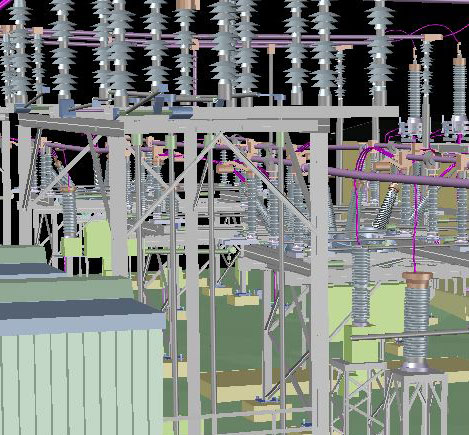
Here’s a little substation eye candy compliments of our own CJ Ruch and Dan Palmer, Laser Scanning Technicians extraordinaire!
Maser Consulting’s Static Laser Scanning department was tasked with scanning and modeling an electrical substation located in the US Northeast. The field scanning portion of this job required set-ups at 34 individual locations. The client was provided with a deliverable that included a model in AutoDesk Civil3D format. The cleaned and unified point cloud consisted of approximately 3.4 billion points contained within a roughly 63 GB database. CJ used Leica Cyclone to model all the substation components, while Dan Palmer used Edgewise from ClearEdge 3D to model all of the steelwork.

 “In our experience, we have found that utilizing multiple software applications and taking advantage of many programs’ individual strengths enables us to create a comprehensive model deliverable while providing an affordable price” explained CJ. “We’ve used similar strategies with Autodesk Revit and Cyclone in the past to produce other forms of modeling. Above all, laser scanning provides us with a method of obtaining accurate 3D object spatial data from challenging and potentially hazardous environments from a safe, remote distance.”
The final model consists of over 25,000 individual Cyclone primitives and EdgeWise Steel objects. The individual Cyclone primitives are used as subunits, combined in a way to accurately represent the components found on this site. Everything, from the insulators to the largest substation components, can be modeled to provide a visually relevant, fully measurable and geo-referenced model that can be used for object placement conflicts, inventory and emergency management.

April 03, 2017 at 7:47 pm, Drew said:
Looks good CJ, great job!