Category: GIS
-
What Actually Is GIS?
When I went to college down in Florida, I took an environmental science class with one of my friends, Madelyn. One of her minors was in Geographic Information Systems (GIS), and as the confused communications major, I had no idea what it meant. In this environmental science class, our professor described GIS as fancy maps,…
-
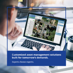
Full-Service Asset Management System in Brick Township, NJ
We partnered with the Brick Township Municipal Utilities Authority (BTMUA) to enhance their existing asset management program.
-
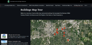
Discover Local History With a Click of Your Mouse
The Benbow Park neighborhood in the City of Greensboro, North Carolina is filled with a rich history. Richard Barron and Nancy McLaughlin at Greensboro.com report that the City is documenting its history with a new ,000 grant from the National Parks Service’s African American Civil Rights program. This enables an architectural historian to document historic…
-
Mobile and Web GIS: Communicating with the General Public
Learn how mobile and web-based Geographic Information Systems (GIS) story maps help towns and communities come together and increase engagement!
-
GIS in the Classroom and in Action!
In GIS 1, we heard from an employee who reports to the client’s office instead of one of our own. Then, in GIS 2 we heard from two employees who both split their time between working in the field and in their offices. Welcome to GIS 3! We are hearing from Peter Erlenbach, who is…
-
From Office to Field: GIS Workers Unite
Welcome to the second segment of our GIS 123 series! Last time we learned how one Colliers Engineering & Design employee stays connected to us while working from a client’s office. This time, we are going to hear what it’s like to be employees who work simultaneously in the field and office from two completely…
-
Adapting Your Work Environment to Better Serve Clients
As our company has grown and transitioned, so has our GIS department expanded, enabling us to better serve our clients. We are presenting GIS-123, a 3-part series of blogs focused on the personal perspectives of GIS employees. They work directly with clients from the field and in the office, wherever that may be. If you…
-
A Look at GIS: You’ve Come a Long Way, Baby!
Discover and learn how a GIS program can help organize the management of key infrastructure assets! [vc_row][vc_column][vc_video link=”https://youtu.be/cftVlMekXno”][/vc_column][/vc_row][vc_row][vc_column][vc_column_text] Geographic Information Systems. Think about it. GIS locates assets in the field with Global Positioning System accuracy. GPS is a satellite-based system that, in the right conditions, can hone-in on an object from space within a few…
-
Geographic Information System (GIS): The Ultimate Guide
What is GIS? A geographic information system (GIS) is a framework for gathering, managing, and analyzing data. It integrates many types of data. It’s rooted in the science of geography and is an extension of cartography – the science of making maps. According to Discipline Leader of GIS Asset Management Services Suzanne Zitzman, it’s built…
-
GIS: Getting Started with the Water Quality Accountability Act
As more processes and documents are being moved to web-based programs, it makes sense that local government, an industry with many complicated procedures, would gravitate to do the same. And with the Water Quality Accountability Act requiring owners of water distribution systems to GPS locate utilities, there’s a need to move online more than ever.…
-
Municipalities Unite at the 2015 NJSLOM Conference & NJSME Awards
In New Jersey, the largest municipal event by far is heralded in by the NJ State League of Municipalities’ (NJSLOM) Annual Conference held within the casinos of Atlantic City, NJ. This 3-day long event is filled with handshaking, info-booths, making friends, enjoying the festivities, developing business contacts and a chance to compare notes with any one of the 565 municipalities…