Mobile Mapping Underground: They Said it Couldn’t be Done
Built to connect a network of surface track and underground tunnels, a railway system on the east coast was tasked with the systemwide installation of cellular service to provide increased safety and connectivity. While cellular service had already been available in all the train stations, there was still no continuous service available inside the tunnels, some of which were as much as 26 miles long underground.
Constructed by assorted contractors, this unique system spans over 100 miles, has nearly 100 stations and provides service for more than 600,000 customers a day.
Converging as a cohesive entity, the track weaves back and forth, over and under, three states. The tunnels, which were built at various points in time, were hewn through rock and other materials on different terrains creating an inconsistency in the exact configuration of tunnel interiors.
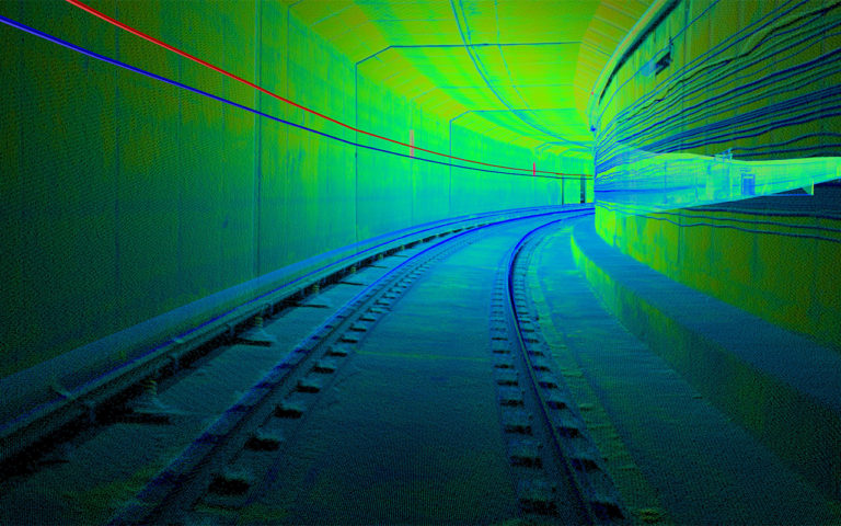
In order to design and build a modern communication system, a highly accurate as-built map of the entire system had to be created. Once completed, a series of cables could be attached to the tunnel walls that would provide the needed cellular service. Because the tunnel’s dynamic envelope has such limited space within, this map had to be of the highest quality available. Today we have the technology to do this and it’s called LiDAR. Light Detection and Ranging is a technology that uses sensors to scan a subject by sending out a physical pulse of light that measures distance based on the time of flight between when the pulse leaves the sensor and when it is reflected back and returns. This high-definition technology is so dense that it can measure over a million points per second per sensor. The term Mobile LiDAR refers to mounting high-accuracy mobile mapping scanners, in this case, to the top of a hi-rail truck that traverses the railway and scans while in motion. Mobile LiDAR depends on the use of Global Positioning (or GPS) technology for positional accuracies. Given that the tunnels were underground where GPS signals are not present, another method was needed. The team at Colliers Engineering & Design worked closely with the authority to develop a way to trick the GPS. So, how did they do it?
The Team
First, the railway authority had to find a team of professionals who were up for this challenge and approached Colliers Engineering & Design, at the time Maser Consulting–on their conviction that it could be done. Not only did the team have the right combination of equipment, after a great deal of discussion the authority was convinced they had a viable approach and qualified team, so they championed the innovation.
“No one had ever performed mobile mapping underground for more than a few miles,” said Paul DiGiacobbe, Director of Geospatial Services at Colliers Engineering & Design. “We knew it would be difficult, given the challenging geometry and sheer length of the tunnels.”
The project team, consisting of three full-time survey crews, the Mobile LiDAR team, and key members from the authority, performed a 10-mile pilot study in which the initial results were validated and further substantiated the team’s confidence in the project’s success.
“The pilot study was key because it gave us the opportunity to learn how to deal with the performance of the Mobile LiDAR system without GPS,” explained Clay Wygant, Mobile LiDAR Manager at Colliers Engineering & Design. “We captured enough data to test and confirm our tunnel mapping theory. This set us up for success for the remainder of the tunnel system.”
Continue reading here.